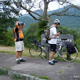
The Blue Ridge Parkway links the Great Smoky Mountains in NC to the Shenandoah National Park in VA. We are starting at the official end of the parkway (Milepost 469) near Cherokee, NC.
It turns out the southern end is also the highest point on the parkway rising to 6047 feet above sea level. When people asked us how far we planned to ride our answer quickly became as far as our legs would take us, as the first 10 miles go almost straight up at 6-10 degree grades.
Our plan for this section of the parkway it to have our wives stay in camp near the Southern End and use the car to "rescue" us when we have gone as far as possible.
Today's ride turned out to be a slight departure from this plan as we rode about 10 miles to an elevation of 5150 feet, and then decided it would be easier to simply coast back to the start and have them pick us up back at the base.
The ride was like two completely different experiences. Going up we averaged about 4 MPH and took lots of breaks to catch our breath. The four tunnels we passed through were scary because you hoped the cars would see us as we slowly made our way through the darkness.
Coming down, we averaged about 25 MPH and the tunnels were scary because riding 20-30 MPH into almost complete darkness on a road surface that was sometimes littered with gravel conjured up images of really nasty road rash.
Plan is to have Vicki drop us off at the point we reached yesterday where today we hope to make better time or this is going to be a very long ride!
Thanks to everyone who has been commenting here or on Facebook - your words of encouragement or stories help keep us pedaling.
 |
| Jul 26, 2009 |

No comments:
Post a Comment